Randonnée V.T.T. Val d'Arry - Le Locheur 2009 50Klm - Photo

Le Locheur 2009 50Klm

 tracegps
tracegps

Utilisateur

© OpenStreetMap contributors
Longueur
Longueur
50 km
Altitude max
Altitude max
187 m
Dénivelé positif
Dénivelé positif
763 m
Km-Effort
Km-Effort  
60 km
Altitude min
Altitude min
50 m
Dénivelé négatif
Dénivelé négatif
766 m
Boucle
Boucle
Oui
Date de création :
2014-12-10 00:00:00.0
Dernière modification :
2014-12-10 00:00:00.0

(0 Avis)

V.T.T.
V.T.T.
3h30
Difficulté : Moyen

Scannez ce code QR pour ouvrir la randonnée dans l'application SityTrail

Application GPS de randonnée GRATUITE

Logo SityTrail SityTrail

IGN / Instituts géographiques

Télécharger SityTrail sur l'App Store Télécharger SityTrail sur Google Play

Logo SityTrail SityTrail World

Le monde est à vous

Télécharger SityTrail sur l'App Store Télécharger SityTrail sur Google Play Télécharger SityTrail sur Huawei AppGallery

À propos

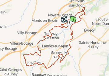
Randonnée V.T.T. de 50 km à découvrir à Normandie, Calvados, Val d'Arry. Cette randonnée est proposée par tracegps.

Description

Peu de grosses difficultés pour ce parcours mais des sentiers sympathiques, de jolis paysages et une intensité constante. L'automne permet de transformer tout VTTiste en Hippopotame soucieux de sa peau.

Profil altimétrique

Points d'intérêt

Point d'intérêt Val d'Arry - la locheur 2009 49.846 km - Photo
tracegps

Localisation

Pays :
France
Région :
Normandie
Département/Province :
Calvados
Commune :
Val d'Arry
Localité :
Le Locheur
Départ:(Dec)
Départ:(UTM)
678930 ; 5442118 (30U) N.

Randonnées à proximité

Randonnée Marche Val d'Arry - le locheur-01 - Photo
Marche
gr1346

Marche

Moyen
(1)
Val d'Arry, Normandie, Calvados, France
8,4 km | 10,1 km-effort
2h 17min
Oui
Randonnée Marche Gavrus - gavrus08 - Photo
Marche
gr1346

Marche

Moyen
Gavrus, Normandie, Calvados, France
8,5 km | 9,7 km-effort
2h 6min
Oui
Randonnée Marche Parfouru-sur-Odon - Parfouru - Photo
Marche
gr1346

Marche

Moyen
(1)
Parfouru-sur-Odon, Normandie, Calvados, France
9,8 km | 12,1 km-effort
2h 36min
Oui
Randonnée A pied Val d'Arry - Autour de Le Locheur - Photo
A pied
PRO

A pied

Facile
Val d'Arry, Normandie, Calvados, France
7,9 km | 9,6 km-effort
2h 10min
Oui
Randonnée A pied Landes-sur-Ajon - De l'Ajon à l'Odon - Photo
A pied
PRO

A pied

Facile
Landes-sur-Ajon, Normandie, Calvados, France
13,2 km | 16,7 km-effort
3h 47min
Non
Randonnée Marche Sainte-Honorine-du-Fay - st hono dufay  - Photo
Marche
yannick14

Marche

Difficile
Sainte-Honorine-du-Fay, Normandie, Calvados, France
10,6 km | 13,5 km-effort
3h 4min
Oui
Randonnée V.T.T. Évrecy - 1er vttae 14062023 - Photo
V.T.T.
cedric14

V.T.T.

Moyen
Évrecy, Normandie, Calvados, France
24 km | 28 km-effort
1h 38min
Oui
Randonnée V.T.C. Bougy - VELO CAEN 2 - Photo
V.T.C.
UDGI54

V.T.C.

Très difficile
Bougy, Normandie, Calvados, France
40 km | 45 km-effort
3h 7min
Oui
Randonnée Marche Gavrus - Gavrus - Photo
Marche
papylou7

Marche

Difficile
Gavrus, Normandie, Calvados, France
14 km | 16,8 km-effort
3h 48min
Oui


Fermer
Mes abonnements